Zoning in Andover Massachusetts: Difference between revisions
No edit summary |
No edit summary |
||
| (66 intermediate revisions by 2 users not shown) | |||
| Line 1: | Line 1: | ||
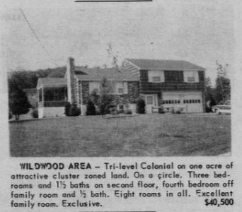
In 1960, Andover adopted 'cluster zoning' <ref> https://dspace.mit.edu/handle/1721.1/73317 | [[File:Wildwoodhome.jpg|150px|frame|right|alt=This Wildwood area home boasts "cluster zoned land." Andover Townsman, May 1970|This Wildwood area home boasts "cluster zoned land." Andover Townsman, May 1970]] | ||
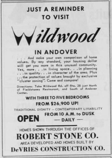
[[File:Visit Wildwood.jpg|150px|frame|right|alt=This advertisement for the new Wildwood Acres in an Andover Townsman advertisements lists "exclusive" cluster zoning as a value-added feature of the properties in the development. |This advertisement for the new Wildwood Acres in an Andover Townsman advertisements lists "exclusive" cluster zoning as a value-added feature of the properties in the development. ]] | |||
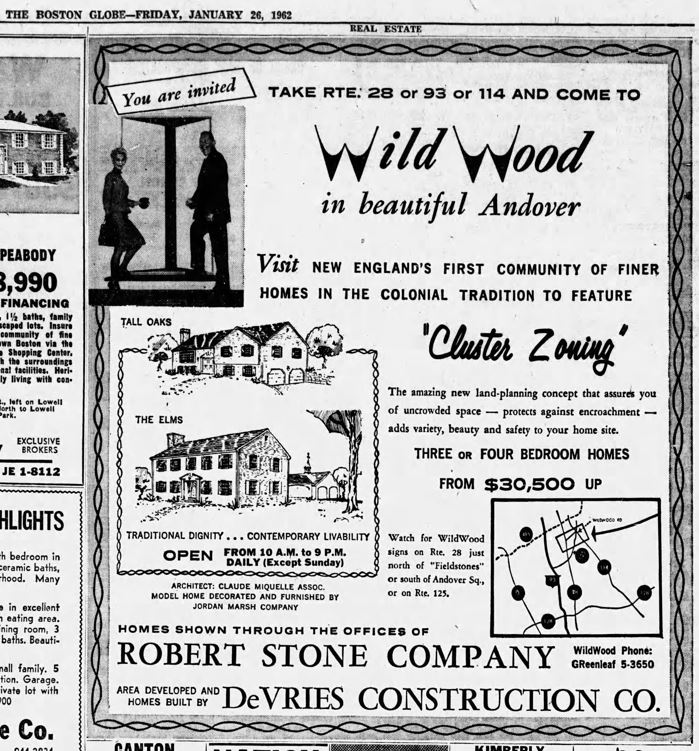
[[File:FirsttoFeature.jpg|100px|frame|right|alt=This Boston Globe ad for Wild Wood from January 1962 boasts New England's first cluster zoning community|This Boston Globe ad for Wild Wood from January 1962 boasts New England's first cluster zoning community]] | |||
Andover's first zoning by-law was enacted at the March 9, 1936 Annual Town Meeting. <ref> Estimate $29.50 rate; zoning law passed, ''The Andover Townsman'', March 13, 1936. </ref> <ref> Andover Zoning Law Approved, ''The Boston Globe,'' April 12, 1936. </ref> The Town of Andover's first Planning Board had been voted into law ten years earlier. <ref> [https://archive.org/details/annualreporto19261929ando/mode/2up Annual Report for the Town of Andover, 1926] </ref> | |||
In 1959, a new regional planning district, The Central Merrimack Valley Planning District, was established as directed by a state regional planning law passed in 1955. Representatives from the City of Lawrence and the towns of Andover, North Andover, and Methuen were appointed to the advisory board whose role was to establish coordinated regional planning projects in the midst of rapid regional expansion, a new circumferential highway ([https://en.wikipedia.org/wiki/Interstate_495_(Massachusetts) 495]) and other rapidly changing factors such as the industrial zones, water, housing and infrastructure. <ref> [https://archive.org/details/annualreporto19551959ando/page/128/mode/2up Annual Report of the Town of Andover, 1955] </ref> | |||
In 1960, Andover adopted 'cluster zoning,' the first town in Massachusetts to create special development by-laws that allowed sub-divisions of ten acres or more to create residential lots sized smaller that the required two acres and for them to have frontages that were less than the required existing laws permitted. <ref>[https://dspace.mit.edu/handle/1721.1/73317 Clement, John Roland. Massachusetts Institute of Technology. Dept. of City and Regional Planning. Thesis. 1966. M.C.P] </ref> <ref> First cluster zoning in state ''The Boston Globe,'' January 21, 1962. </ref> <ref> All eyes on Andover cluster development, ''The Boston Globe,'' November 20, 1961. </ref> <ref> New cluster zoned houses for Andover, ''The Boston Globe,'' January 14, 1962. </ref> | |||
In the 1960s, in the wake of the newly announced [https://en.wikipedia.org/wiki/Interstate_495_(Massachusetts) 495] highway construction project, in an effort to slow development multiple citizen-led o pass a two-acre minimum lot size for new home construction failed. <ref> Merrimack Valley uneasy about the growth of towns, ''The Boston Globe,'' September 9, 1962. </ref> <ref> Suburban towns wrestle with zoning woes ''The Boston Globe,'' October 12, 1960. </ref> <ref> Route 495 to affect 75 towns, ''The Boston Globe'', April 10, 1961. </ref> | |||
In 1960, in response to a surge in new housing builds, the planning board proposed a two-acre lot restriction in West Andover and near Haverhill Street. Town meeting rejected that plan. <ref> Two acre zoning beaten in Andover, ''The Eagle Tribune,'' "March 15, 1960. </ref> | |||
West Andover zones for industrial development were expanded in the late 1950s and throughout the 1960s. | |||
In 2015, The Town of Andover approved The Historic Mill District at the May Annual Town Meeting. The Historic Mill Distric is an area of over 100 acres including the Town Yard, commercial, residential and open space properties in downtown Andover. <ref> Town Meeting okays mill district proposal, The Andover Townsman, May 14, 2015. </ref><br><br> | |||
'''Relevant Federal and Massachusetts State Planning/Housing/Zoning Laws and Projects'''<br> | |||
*In 1955, Massachusetts passed a Regional Planning Law.<br> | |||
*In 1969, Massachusetts enacted the [https://en.wikipedia.org/wiki/Massachusetts_Comprehensive_Permit_Act:_Chapter_40B Massachusetts Comprehensive Permit Act] which allowed developers of affordable housing to override local, municipal restrictive zoning by-laws to build multifamily and high density housing as a solutionn to the affordable housing crisis. The new law was the first of its kind in the country. <br> <ref> Senate Votes Low-Cost Housing in Suburbs, ''The Boston Globe,'' August 13, 1969. </ref> <br> | |||
*In 2004, Governor Mitt Romney passed a law creating financial incentives for municipalities and towns to zone and permit more multifamily, apartment and condominium housing near public rail stations. | |||
'''SEE ALSO''' <br> | |||
[https://andoverma.gov/191/Zoning-Board-of-Appeals Town of Andover Zoning Board of Appeals] <br> | |||
[https://andoverma.gov/DocumentCenter/View/10817/Andover-Zoning-Bylaw-32122 Town of Andover Zoning By-law, revised 2022] <br> | |||
[https://andoverma.gov/DocumentCenter/View/1573/Zoning-Overview-for-Beginners-2017?bidId= Andover Zoning for Beginners] <br> | |||
[https://mvlc.ent.sirsi.net/client/en_US/andover/search/detailnonmodal/ent:$002f$002fSD_ILS$002f0$002fSD_ILS:1595945/one Map of the Town of Andover, Made for the Planning Board, 1955] <br> | |||
[https://mvlc.ent.sirsi.net/client/en_US/andover/search/detailnonmodal/ent:$002f$002fSD_ILS$002f0$002fSD_ILS:1595945/one Proposed Zoning Map, 1956]<br> | |||
[https://archive.org/details/new-housing-in-andover-do-we-gain-or-lose-report New Housing in Andover Do We Gain or Lose ] <br> | |||
[https://archive.org/details/apartment-housing-in-andover-gain-or-loss-march-6-1962 Apartment Housing in Andover Gain or Loss?] | |||
'''REFERENCES''' | |||
<references /> | |||
--[[User:Stephanie|Stephanie]] ([[User talk:Stephanie|talk]]) 12:44, 28 March 2024 (EDT) | |||
Latest revision as of 15:45, 29 March 2024


Andover's first zoning by-law was enacted at the March 9, 1936 Annual Town Meeting. [1] [2] The Town of Andover's first Planning Board had been voted into law ten years earlier. [3]
In 1959, a new regional planning district, The Central Merrimack Valley Planning District, was established as directed by a state regional planning law passed in 1955. Representatives from the City of Lawrence and the towns of Andover, North Andover, and Methuen were appointed to the advisory board whose role was to establish coordinated regional planning projects in the midst of rapid regional expansion, a new circumferential highway (495) and other rapidly changing factors such as the industrial zones, water, housing and infrastructure. [4]
In 1960, Andover adopted 'cluster zoning,' the first town in Massachusetts to create special development by-laws that allowed sub-divisions of ten acres or more to create residential lots sized smaller that the required two acres and for them to have frontages that were less than the required existing laws permitted. [5] [6] [7] [8]
In the 1960s, in the wake of the newly announced 495 highway construction project, in an effort to slow development multiple citizen-led o pass a two-acre minimum lot size for new home construction failed. [9] [10] [11]
In 1960, in response to a surge in new housing builds, the planning board proposed a two-acre lot restriction in West Andover and near Haverhill Street. Town meeting rejected that plan. [12]
West Andover zones for industrial development were expanded in the late 1950s and throughout the 1960s.
In 2015, The Town of Andover approved The Historic Mill District at the May Annual Town Meeting. The Historic Mill Distric is an area of over 100 acres including the Town Yard, commercial, residential and open space properties in downtown Andover. [13]
Relevant Federal and Massachusetts State Planning/Housing/Zoning Laws and Projects
- In 1955, Massachusetts passed a Regional Planning Law.
- In 1969, Massachusetts enacted the Massachusetts Comprehensive Permit Act which allowed developers of affordable housing to override local, municipal restrictive zoning by-laws to build multifamily and high density housing as a solutionn to the affordable housing crisis. The new law was the first of its kind in the country.
[14] - In 2004, Governor Mitt Romney passed a law creating financial incentives for municipalities and towns to zone and permit more multifamily, apartment and condominium housing near public rail stations.
SEE ALSO
Town of Andover Zoning Board of Appeals
Town of Andover Zoning By-law, revised 2022
Andover Zoning for Beginners
Map of the Town of Andover, Made for the Planning Board, 1955
Proposed Zoning Map, 1956
New Housing in Andover Do We Gain or Lose
Apartment Housing in Andover Gain or Loss?
REFERENCES
- ↑ Estimate $29.50 rate; zoning law passed, The Andover Townsman, March 13, 1936.
- ↑ Andover Zoning Law Approved, The Boston Globe, April 12, 1936.
- ↑ Annual Report for the Town of Andover, 1926
- ↑ Annual Report of the Town of Andover, 1955
- ↑ Clement, John Roland. Massachusetts Institute of Technology. Dept. of City and Regional Planning. Thesis. 1966. M.C.P
- ↑ First cluster zoning in state The Boston Globe, January 21, 1962.
- ↑ All eyes on Andover cluster development, The Boston Globe, November 20, 1961.
- ↑ New cluster zoned houses for Andover, The Boston Globe, January 14, 1962.
- ↑ Merrimack Valley uneasy about the growth of towns, The Boston Globe, September 9, 1962.
- ↑ Suburban towns wrestle with zoning woes The Boston Globe, October 12, 1960.
- ↑ Route 495 to affect 75 towns, The Boston Globe, April 10, 1961.
- ↑ Two acre zoning beaten in Andover, The Eagle Tribune, "March 15, 1960.
- ↑ Town Meeting okays mill district proposal, The Andover Townsman, May 14, 2015.
- ↑ Senate Votes Low-Cost Housing in Suburbs, The Boston Globe, August 13, 1969.